Property Aerial with Utility Routing Paths (Annotated)
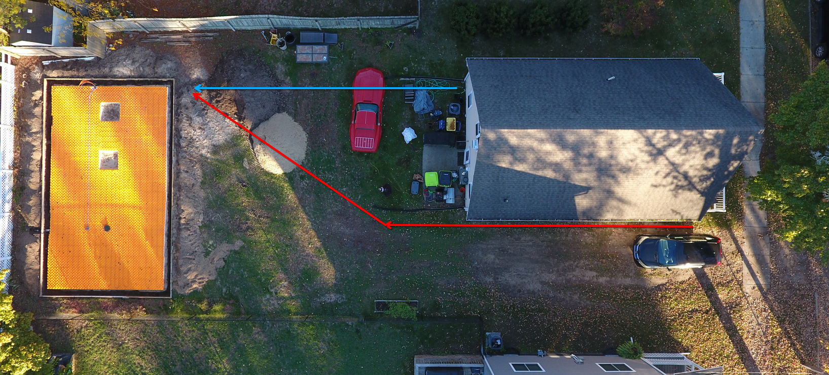
Photo Details
- Date: October 25, 2025
- Weather: Clear morning transitioning to overcast afternoon, 39-53°F. Excellent conditions for aerial photography and documentation.
- Phase: Planning - Utility routing documentation
- Location: 309 E. 7th St., Clare, MI
- View: Cropped aerial view with utility routing annotations
- Equipment: DJI Phantom 4 Pro
- Base Image: DJI_0005 (cropped and annotated)
Description
This annotated aerial photo shows the planned underground utility routing from the existing house to the new garage foundation. The image is cropped from DJI_0005 to focus on the project site and provides better detail for the proposed utility paths.
Utility Routing Annotations
RED Arrow - Electrical Service Path (Trench 1)
- Route: House SW corner → Garage foundation (separate dedicated trench)
- Service: 200A wire capacity, 100A initial connection
- Why Separate: Electricians’ consensus that electrical should run in its own trench
- Connection Point: House SW corner where power enters basement to 200A main panel
- Specifications: See Trench 1: Electrical Service (RED arrow path)
BLUE Arrow - All Other Utilities Path (Trench 2)
- Route: House connection point → Garage foundation (bundled trench)
- Utilities Included:
- Sewer (3” PVC pipe)
- Natural Gas (1” PE polyethylene pipe minimum)
- Water (3/4” PEX maximum)
- Low Voltage (2” PVC conduit for fiber/network/data)
- Why Bundled: Cost efficiency, single excavation, similar burial depths
- Specifications: See Trench 2: All Other Utilities (BLUE arrow path)
Visible Elements
- Garage Foundation (left side):
- Orange Creatherm insulation visible
- Through-foundation conduits already installed (as of 2025-10-22)
- 1x 3” PVC for sewer, 4x 2” PVC for other utilities
- Both utility paths terminate at this location
- Main House (right side):
- Light blue/gray house with dark roof
- Electrical service entry point at SW corner (RED path)
- Other utilities connection point TBD (BLUE path)
- Property Layout:
- Clear view of yard space between house and garage
- Both trenches will traverse backyard area
- Access for excavation equipment visible
- Site Context:
- Neighboring properties on both sides
- Fall foliage throughout
- Vehicles on property (red car, blue tarp, propane tank)
Two-Trench Strategy
This image illustrates the critical decision to use two separate underground trenches rather than one combined trench:
Trench 1 (RED): Dedicated electrical service
- Different burial depth requirements (NEC)
- Separation from gas and water for safety
- Independent contractor and timeline
- Easier future maintenance and troubleshooting
Trench 2 (BLUE): Bundled non-electrical utilities
- Cost efficiency (single excavation)
- Coordinated plumber/HVAC installation
- Similar burial depths for all utilities
- Reduced property disruption
Both trenches converge at the garage foundation where utilities enter through pre-installed conduits into the mechanical room.
Strategic Value
This annotated image provides:
- Visual documentation of utility routing decisions
- Clear communication tool for contractors
- Reference for excavation planning and coordination
- Record of electricians’ rationale for separate electrical trench
- Future reference for maintenance and troubleshooting
Related Documents
- Utility Planning: House-to-Garage Utility Routing Strategy
- Electrical Design: Main Electrical Service
- Source Document: utility-conduit-details
- Base Image: DJI_0005 (wide property view, uncropped)
- Construction Progress: Initial Build
- Contractors: Jonas Hershberger